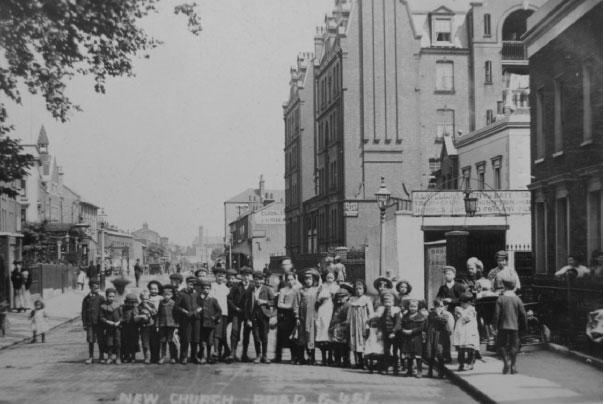
New Church Road was originally laid out as an elegant approach road to St.George’s church – new at the time – but contained some poor housing by 1898. After the war, houses started to be cleared and prefabs were built in this area of the park. Back down New Church Road, outside the park, stands Evelina Mansions. With its decorative flourishes of brick and ironwork, it was built to provide decent accommodation for the urban working classes.
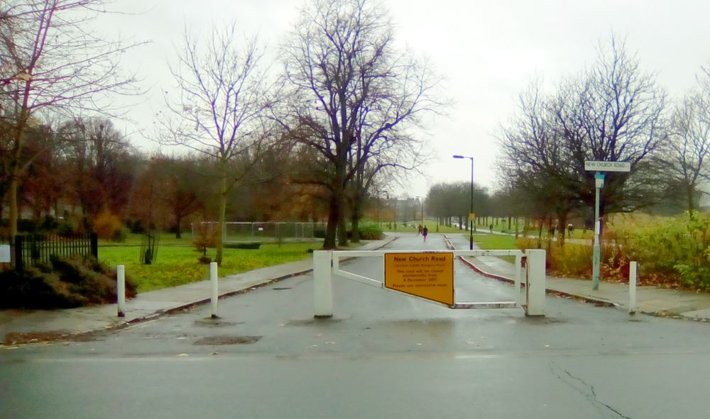
New Church Road was one of the last ‘ghost roads’ of Burgess Park – residual streets left stranded amidst green space as the park developed. Just tarmac and kerbs without traffic, buildings, or borders. Closed to traffic in 2003, it served as an echo of times when this area was densely built over, and bustling with homes and businesses. Over nearly 200 years, it saw a whole community come and go. Finally, it was removed in 2018 and barely a trace remains.
The road was originally built around 1826, chiefly to allow horse and carriage to drive from Walworth Road right up to the new St. George’s church, passing alongside the Grand Surrey Canal as it did so. The moneyed Georgian couple could arrive in all their finery, and in some comfort, for Sunday prayers.
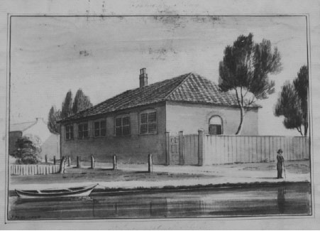
Such a trip would pass the St.George’s National School, facing the canal on the north bank. The National Schools were established throughout England and Wales from 1811 onwards. They offered an elementary education to the children of the poor – one specifically in line with the teachings of the Church of England. Before about 1800, apart from the few charity schools, poorer children had little chance of any formal education.
Originally little more than a hall, it was rebuilt in 1840 – enlarged, relocated to the south side of the canal, and in handsome Elizabethan style – “the ground plan of which preserves the usual form of buildings referable to the era of the maiden Queen”. Or in plain English, the new school building was shaped like a letter E, for Elizabeth. It now served 450 boys and girls – with separate entrances, of course.
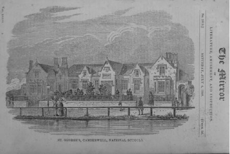
The school remained open until WWII, but sustained major bomb damage, ultimately relocating to its current location on Coleman Road, just south of the park.
At the other end of New Church Road, stands the elegant redbrick Evelina Mansions block, emblazoned with the badge of the Four Per Cent Industrial Dwellings Company. Founded in 1885 by Jewish philanthropists, the company originally aspired to improve housing and combat overcrowding amongst the poor of London’s East End, particularly among Jewish women. Later it expanded to other parts of London, such as here in Southwark. The block was erected in 1900, containing 96 one or two bed flats. The curious ‘Four Per Cent’ name is variously said to be the interest rate of return that an investor might aspire to on the properties, or the percentage Jewish population in the UK back in 1885.
What of regular housing? New Church Road was lined with 2 and 3 storey terraces. Though slightly grander than some of the smaller artisan dwellings elsewhere, they were no less subject to subdivision, bomb damage, and ultimately planning blight. From the 1950s onwards, as elsewhere across the area, plots of land were bought one by one, and cleared for inclusion into the new park.
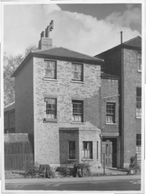
Among the many street photos that exist of the area after World War 2, one stands out. It hints intriguingly at what might have been, had Burgess Park not been dreamt up. Dated 1952, it is captioned “unfit house rendered fit for habitation”. How different things might have looked today if the Abercrombie vision of gradual clearance and acquisition had never occurred!
There are many interesting photos of the buildings in New Church Rd on the LMA website:
(with thanks to Steve Matts)
Watch the Slaves video ‘Cheer Up London’ shot in New Church Rd in 2015 here!
Hi My Grandparents lived at Number 67 New Church Road Bermondsey at the time of the 1911 Census.
Do you have any information or any other photos taken at the time which by chance may be Number 67.
Many Thanks
I’m afraid this will take some investigation in the Southwark Local History Library, where they do have many images which may cover the period you’re interested in.
I remember the house in the foto very well. The double doors to the right led through the house to another set of double doors into a yard fronting a hall that contained a stage. It was used for storage but what it had originally been I don’t know.
It was used by scenery artists for various. Theatres and Music halls in the area. There also were scenery firms in King and Queen St, SE17. Mara Vista I think was one. Backcloths were made for the Royal Opera House. The Manse which is where the tree is on the left side of the photo had a drill hall, and it is where recruitment for the Easy Surrey Regt & Queens & Royal Horse Artillery was started then later on moved to the barracks at Flodden Road off Camberwell New Road, behind what was Tolers garage.
Interesting! My great aunt lived at the very same address (67 New Church Road) following the war, all the way through to 1956.
Hi my parents, Mr and Mrs Kashano, lived near Verney Road, Bermondsey. My siblings went to Ilderton Road Primary.
However, I am at a loss in checking the map of Bermondsey for 1952 as Mum used to mention that she lived at Golders Street. However, on checking the maps, I cannot find such a street.
Could it have been demolished?
I also want to know information on the type of dwellings in that area.
I am basically looking into what the area/neighbourhood was like when my Mum and Dad came over here from Cyprus in 1952.
Hi Pelin
In a quick search I also can’t see any Golders St. The area you mention is away from Burgess Park, on the other side of Old Kent Road. I checked out this map: https://maps.nls.uk/view/101202210 where you can see Ilderton Road Primary just to the right of the centre. Anyone else got any ideas?
Goldie Street was at the Eastern end of Neate Street. I have a 1965 A to Z which shows the road. The road was on the Northern side and was made of two squares in a rectangle abutting Coburg Road and the road coming out opposite the Bee Hive PH (which looked great).
Of course – maybe it’s Goldie not Golders!
Hello I’m back here still researching and found a page ‘London Remembers’ about Burgess Park with an old map showing Goldie Street which is now part of Burgess Park.
And the interesting fact: my late Dad used to go to Peckham Mosque which is in fact in Burgess Park and based not far from where Goldie St was.
If anyone has any stories, pictures of the neighbourhood of Goldie St please do share. Mum had great stories of the community. I do know that the houses had no bathroom and people had to visit the local baths or bath houses?
Absolutely fascinating – I’ve loved reading all comments from people who used to live around the area. I’ll have to go on a tour with my sister who lived there as a child
My great grandfather, Alfred William Garrard, had “coffee rooms” at 5 New Church Road, according to a 1920 business directory recently added to the Ancestry subscription website. Is it possible to find out anything more about it, e.g. how long it was there for, did it have a name (other than perhaps “Garrard’s”)? I now live in Cheshire, so not very easy to access local archives unless they’re put online!
Alfred William Garrard was my great great great grandfather. I am also researching him now. It is very interesting. Please do get in contact if you have further information that can help me or if you want to know more!
Hi Kimberley – Email sent, looking forward to exchanging information!
Hi there David and Kimberley! I hope this finds you well. I’m doing a little bit of research into where I currently live on the small stretch of New Church Road between numbers 1 – 19. I was fascinated to hear of your relative’s Coffee Rooms at number 5! I wonder if you have come across any other sources or information about the business or indeed the street itself?
My Grandparents, the Hodges, lived with their children, (my mum and her siblings) in Evelina Mansions during WW2
Thank you so much for this information. I am currently researching my family tree and discovered my great grandfather lived at number 144 New Church Road and was baptised in St Georges. My great aunt who is in her late 90s really enjoyed learning more about this.
Hi Matt,
My Grandfather Jack Evans lived at 142 New Church Road and relatives lived at 144 and I believe 146. I remember visiting 142 with my mum to visit my Grandmother many times.
The Evans family were wheelwrights.
Hi Matt and Jenny
My Great Great Grandfather was George William Evans, the wheelwright. He lived at 144 Church Road before later moving to Leicester Road in Barnet. I believe we have made contact though Ancestry in the past (Jenny). How lovely to see a new name – Hello Matt. Feel free to contact me through ancestry to share info.
How lovely to have some photographs of where our ancestors lived!
Hi Natalie my Husband Terence Evans’ Grandfather was also George William Evans of that address. He also has sisters Pat, Lilian brothers Ron and George now passed, my Husband’s father was Richard George William Evans. We have been looking for any photos of the barrows
Hi, Jack Evans was also my grandfather. My father was his son also called Jack Evans. I also visited there but have scant memories!
Evans the builders were at the bend on NCR near the Church. The Chappells lived across the road until WW2 when bombed out. A large yard and a small block of flats which had one side side burnt out. (I think it was the bomber that hit ours and the canal starting a rush of water swamping all the houses near the bend).
My Great grandparents John and Louisa Heath lived at 156 New Church Rd probably from 1886 when they married. He was an accoutrement maker. They had 3 children one of which was my Grandfather, Robert Heath. At the 1911 census he was 19 and a drapers assistant. When he married my grandmother Harriet Ward they also lived at 156 and their 6 children were also born there too . Robert 1914. Albert and Eveline twins, 1915 (Albert was my Father) And 3 other children Richard 1918, Olive 1920, and Vera 1922. I believe they all went to St George’s school. My Father talked about the canal etc. All I can say it must have been quite crowded in their house.
Hi
Lovely to read this.
I have a printed letterhead that my grandfathers CARTER CARRIAGE business was run from 50 New Church Road. In the early 1940s the house he was in must’ve been demolished – I also know he lived at one time in a large lock up yard house – that was later on the front page of the papers as the Richards Gang house. Not sure if it’s this one – or another as he moved about. Cos he was involved in some dodgy stuff himself !
Hi Susan
This is really interesting – we’d love to see the letterhead if you can scan it, and I wonder which paper had the news of the Richardson’s house, and when – it’d be great to have a picture!
Hi. I’ve only just seen this, as going to do some family history. 50 New Church Rd was a gang house since at least the 1930s. I’ve got a 1939 census that shows my grandfather lived there with some other contractors – he moved in after the previous owner was sent to Pentonville. So it was always a gang house. And then the Richardsons gang got hold of it.
My grandfather, Ernest Noyce, was the caretaker of Evelina Mansions from about 1910 until he retired in 1939. He lived at No.1 flat with his wife Grace and three children. My great-aunt Minnie Jorey also lived at No.4 Evelina Mansions for many years until she died in 1970 aged 90. I remember visiting her in the flat as a child. My brother and I went back a few years ago and were surprised to find the road so quiet – your website explains why! We were pleased to see that Evelina Mansions is still going strong.
We lived at number 2 and Mum made Minnie meals. Glad to see your post.
Terry Chappell Seal. Ask the site to pass on my email. It would be nice to talk online. I used to sit and keep Minnie company.
Done!
I think your mum Gladys was friends with my mum Betty Hull. We lived at 46. I was very small, but I do remember mum talking to Minnie and I remember Raymond… your brother?
Hi I attended St George’s mission Primary School new church road Camberwell SE5 next door to a cobblers Hassels Bakers and opposite Southampton way and Evelina Mansions. My era was 1947-1953 but I can never find a photograph of how it was then.
Hi Linda, I am currently researching our family tree with my father John Spring (now in his 80’s). He also attended St George’s st similar time. He remembers a family called ‘Watts’ living in Sugden Street ??
Hi Laura,
My grandfather was also called John spring. Wonder if there’s a connection?
My Great Great Grandfather, according to the 1861 census, lived at 6 Bath Place, New Church Road, Camberwell. I can find no trace of this address. Can you help, please?
Hi Roger
Bath place was close to Addington Square facing onto the canal and has become part of the park now. It was presumably named Bath Place as it adjoined one of the two swimming baths next to Addington Square – see our page about the Square.
I have to inform you(!) that Bath Place was a poor street of very small houses, and by 1889, Charles Booth in his famous maps, marked it down as ‘Very poor, Casual, chronic want’. You can see the area on the Booth Map
Hi Andrew.
Many thanks for taking the trouble to let me know about Bath Place and the interesting map. My G Great Grandfather was a Cork Cutter by trade, as were other members of the family. Not entirely sure what a cork cutter did ( except cut cork!), but obviously didn’t pay well, going by Charles Booth’s remark – ‘chronic want’!. It seems a number of the ‘Boud’ family all came from the Camberwell area.
Once again, many thanks. Much appreciated.
Kind regards and stay safe.
Roger (Boud)
Hi Roger,
I noticed that you mention cork cutter relatives. My great grandfather was a cork cutter, living in Camberwell. He died in 1901 and it seems from census records that one of his daughters took over his job. I have been trying to find out the names of any cork cutting factories in the area to try and locate where he was working. Do you happen to know of any information on names ?
Many thanks in advance.
Kind regards,
Anne Elansary. (Grt grandfather’s name Fred Butler)
Hi,
I was born in 1965 at 113 New Church Road in a prefab!
Was Christened in St Georges Church and attended St Georges Primary School.
Shame we have no picture of that time.
Remember going to see the plans of the park in a caravan and thinking where is a house!!!
Regards Paul
Hi Paul,
I was wondering if you have an older brother named Peter? I remember playing football with a Peter Reeves who lived in the prefabs. I remember one time we went to the Borough (Charles Dickens school?) to train with a team I think was called REDIN FC or similar.
I lived opposite the prefabs (incidentally I recall them as being a modern – for the time – form of prefab) in the 3 storey terraced houses opposite in NCR that were mainly split into separate flats. These flats had only the one street door to access all 3 and without any main door of their own. Consequently, as we lived on the top floor we would walk up via the hall of the bottom flat & the landing of the middle flat. Therefore, the occupants of the middle & bottom flats had very limited privacy.
We also had no bathroom and had to use the scullery sink to wash in and for cooking, washing up, etc – we all survived but looking back it was diabolical that a family of 6 had to live in 3 rooms (because the rear bedroom was uninhabitable due to damp) and this was up to 1970 until we thankfully moved to a 3 double bed terraced house a couple of miles away. I have many memories of growing up in New Church Road and the friends I had there and in Victory Square. The families I can recall in that area are: Davis, Evans, Beamish, White, and a family from Gibraltar. I can remember a couple of factories adjacent to the prefabs, one I think was involved in linoleum manufacture. Further along was the Trinity College Mission – which I believe was attached to Cambridge University. In this building St Georges school was sited until it moved to its new site in Coleman Road in the 60’s.
The cubs and scouts were also sited here and I can remember a trip with the scouts to Guernsey in 1969 that was a great experience. The Ark youth club was run from here as well along with the ‘holiday scheme’ run by Cambridge students, who took the local ‘underprivileged waifs and strays’ on trips to London and the country. This was a great scheme and I can recall going to visit a ship at the Royal Docks and all having afternoon tea on there. On another occasion we were taken to a farm (in Kent I believe) where the farmer or friend had an old bi-plane. We were asked if we wanted to go up for a trip in this and we all formed a queue. Then we were taken up for a spin and looped the loop in it before landing. I know it’s very hard to believe but there wasn’t any form filling that I knew of or health and safety inspectors, in those days to worry about. (I wonder if anybody else remembers this?)
I can remember Ellis the shoe menders, Hassels bakers, Tatnells newsagents, Tobies groceries and Alfie Cocks the greengrocer (a relative told me that Alf had been at Arnhem in the famous battle in the second world war). There was also the scrap yard on the corner of Southampton Way that had the large boat that never went anywhere. I believe the yard is still there but not the boat!
My father’s family had a wood yard next to the Boyton Arms but when the whole area that side of the road was demolished for the park and the yard moved to another location. I have no recollection of this but I have seen photos of the area and it’s amazing how many houses were located between NCR and the canal, in the Boyton Road area!
I could go on and on boring you all but looking back and even though most of the accommodation for families in the area was harsh, it was a great time. We all knew one another and mixed in – obviously there were arguments but they soon ended and no vendettas ensued.
I feel it was far more preferable and an advantage to grow up in that area and time than these present times. Most families were within a short walking distance of their immediate relations and obviously this made it easier for all. It was a great community to grow up in at that time and it’s sad that nothing of the community or buildings exists any longer.
I wonder where everyone went to, once all the buildings were demolished and flattened – it’d be interesting to know. There were many good people in the area and most of the bad ones never bothered anybody not in their business. The last point may be seen as an old worn out cliche but it was true and although people may have become materially richer, socially they have become destitute, compared to pre-1970. It is though only an opinion but one I feel that is shared by many who lived in the communities bordering Burgess park at that time.
All the best to all on this wonderful site and those who grew up in this area – it was a great preparation for life.
Richard.
Hi Richard
I lived in the old houses opposite the prefab in NCR. Our street door was in Victory Square but address was 106 NCR.
My brother sister and myself went back on a nostalgic trip a couple of years ago and pinpointed where our house once stood due to a difference in the kerbstones where victory square once was.
The yard was still there as a reclamation yard…it was a really interesting day and we got several photos and I believe the year after NCR was taken out altogether so no longer exists.
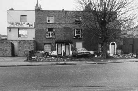
Yes – it was interesting to still see various entrances off New Church Rd, in the turnings and dropped kerbs, marking buildings long since demolished. Now it’s all gone completely, apart from the long-lasting reclamation yard – still there as of December 2020!

Pavement memories – New Church Road looking east
Hi Richard,
Interesting stuff indeed, just looking into the family tree and found that one of my ancestors, Edward Boyton, owned the pub (both of them), Boyton Row and Boyton Place, also heard tell that there was a Boyton owed brewery!
Hi Richard, I am currently researching our family tree and going through memories with my father (now in his 80’s). He remembers Ellis the boot menders, Hassels bakers, Tatnells newsagents, Tobies groceries and Alfie Cocks the greengrocer . He also seems to recall that the pub was the Boyson Arms and Boyson Road area as opposed to Boyton ?? He also recalls a large wood yard .
… and Ron! You can see the pubs on the map on our Pubs page – they were the Surrey Arms Tavern and the Boyton Arms. Check out the details on the PubWiki site – Edward Boyton gets a mention! Also – see the link a couple of comments below this for a picture of the Boyton Arms.
According to to the 1895 and other Ordnance Survey maps, it was Boyton not Boyson, it seems:
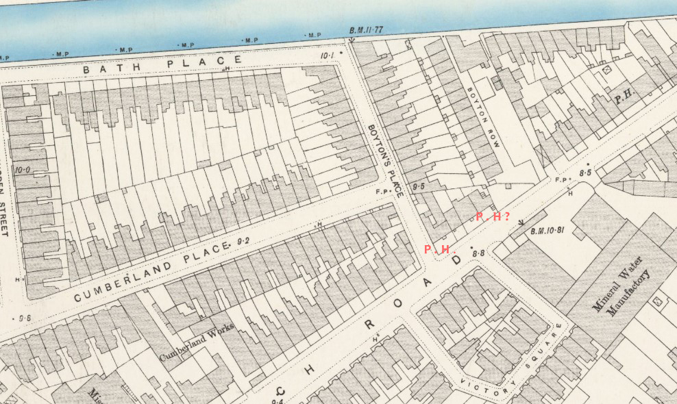
There is a Boyson Road, but it’s off Walworth Road, just north of Albany Road.
If you must write about Evelina Mansions then get it right. 96 flats were there. Because the Seals lived at number 96 & 33. We were the first tenants in 1900 and the blocks were built on the site of a pond. We also lived in numbers 2, 55 & 61 and the last Seals left in the 1990s from Leslie Prince Court. EM was split into four blocks A, B, C, D. The caretaker had the flat at number 1 and there was a door where the rent money was collected through a frosted glass window frame with a small opening section. I still have an old rent book somewhere. Other great families were the Hulls, Lawrences, Slaters, Ancients. The gap behind the yard where Target scrap metal was becoming a cafe run by Andrew hence Andrew’s cafe. Leslie Prince Court was placed on the site of the two.
Hi Terry
Thanks a lot for putting us right on the number of flats – that’s corrected now! I always had the idea that Leslie Prince Court was built on the Richardson’s scrap yard – Peckford. Is that right? There’s a photo taken inside their yard showing the flats across the road in Sears St.
Peckford was the name they traded under, also Target Scrap Metal. Now Peckford might have moved to near the old canal off Albany road on the towpath – there were yards and warehouses for the drying of timber. 1970ish. The old William the Forth pub and other houses.
and also number 75
We lived at no. 77 (96 flats)
We were the Connors – lived at number 82, with the Debonos next to the scrap yard. We are from Malta and the Debonos from Tunis. One bedroom flat – 6 in one bedroom, two bunk beds, two of us in each, and a double bed for mum and dad.
Hi
Just to say, there are some old photos of houses in New Church Rd, on the
”London picture Archive” Here’s the link.
https://www.londonpicturearchive.org.uk/quick-search?q=%27new%20church%20road%27&WINID=1767791111026
Great link, Steve, now incorporated, thanks!
Here’s one from that collection, of the Boyton Arms, in answer to the comment above:
https://www.londonpicturearchive.org.uk/view-item?i=323935&WINID=1767791111026
My 3rd great grandfather Joseph Sharp, was a cow keeper, living on New Church Road, on the 1851 census. There must have still been some fields around then!
That’s a great story! There were certainly open spaces, if they were being built over very rapidly. But I heard that somehow there was a dairy with cows still, in Peckham in the 1950s! (More research needed I think!)
Indeed – it was The Rye that once had cows on, and I believe they were taken over the hill near Nunhead Cemetery. A yard there had cow sheds and I worked there as a mechanic in the 70s – they called it the cowshed. But also near St Georges there were paintings of cows as well. The 1700s. Camberwell was a suburb and then grew fast.
Hi Andrew
(and all who visit this wonderful site)
I have commented on this section of the site 3-4 years Ago – but not since then. However, I do visit and peruse the comments periodically (especially associated to New Church Road) and I have now been prompted to comment again, after seeing the remarks linked to a dairy and farm in the Peckham area and the time it was operating up to.
There have been a few suggestions as to where this site was but I can confirm exactly where the dairy was. It was sited in Lugard Road, Peckham. This is a road that is opposite the southern entrance to Queens road station and towards Nunhead. The dairy farm was owned by a family called Jordan and existed at this site up until approximately the late 1960’s.
I actually visited this site on numerous occasions as a young boy in the 60’s as my father knew Mr Jordan well. From memory I can recall there were at least 20-25 milking cows, all kept in a large cow shed bordered by terraced houses on all sides. There was also the bizarre situation of the cows regularly being given ‘exercise’ via walking down into Lugard Road, via the gate and then being walked around the block.
It seems unbelievable but it was absolutely true and I believe it was the last working dairy that existed in central London. It was a privilege to have witnessed this but as a youngster not realising the significance of it. The site is still there but now occupied by new housing and obviously less interesting!
Mine was a shepherd until he was told to get the flock out of here. Came from the Duke of Beaufort estate. But then, I remember sheep used in Dulwich to keep the grass short. The coming of the 60s cars cut this down.
My great-grandfather, Albert Knight, and his large family lived at 116 New Church Road from 1916 or 1917 until at least 1939. My grandmother, Enid Knight, was also living there in 1925, when she walked up to St George’s Church to get married. Her husband, Bill Bale, had been living with his family at the other end of Walworth Road, in Steedman Street, Elephant and Castle, but after marrying Enid and Bill lived in rented rooms in Albany Road, before eventually moving out to the Becontree estate in Essex.
I am writing a book about Enid’s life, and this Bridge to Nowhere website has been really helpful in bringing her world to life. It has also led me to visit the park where 116 New Church Road once stood, and to see what a fine and popular public amenity it is. Thanks to everyone involved.
My ancestor lived at 173 New Church Rd in the 1851 census in ‘Era Cottage’. Their surname has various spellings – Cattomore, Catomore etc. Henry was a bricklayer/builder and I wondered if you could give me an idea of the houses at that end of the street please? There may have been a mixture of types of dwellings and there is a variety in the link to photos provided earlier! Many thanks. I’m not in the UK so unable to check the library you mention.
Hi Elizabeth
I have found a 1950 map and 173 New Church Road is the last house at the eastern end of the road (that’s where New Church Rd joins Wells Way.)
Something else … 173 is also the nearest of all the houses on New Church Rd to the Surrey Canal.
This map is the one I have used to find the house in which my father was born.
The National Library of Scotland
Map Published 1951
https://maps.nls.uk/geo/explore/#zoom=18.9&lat=51.48171&lon=-0.08905&layers=170&b=1&o=80
This link will show you the numbers on the houses, right click and hold to drag the map around. I hope this link works for you.
If the link does not work, you still have my information about the 173 house location at the end of the road. Hope it helps.
(Unfit house rendered fit for habitation, 1952. Image courtesy of SLHL, ref P13455.) This is the Manze and was opposite Leslie Prince Court the house was marked with a huge tree by the road and on the left of the main NCR photo. The house was an old manor house from the days when this area was known as North Camberwell.
Sorry to say that due to the GLC, they cleared away most of the leftover bombsites and then wiped off the ground the history of the area. Growing up I talked to many older people and found out that before WW2 the area was far from poor but a mix of classes. We all grew up out of necessity and that went back through the ages and made stronger people of the majority.