The Grand Surrey Canal was begun in 1801, with great plans to link the fast-developing docks at Rotherhithe with Mitcham and Portsmouth. It opened as far as Camberwell Road in 1811, with two branches later reaching Croydon and Peckham. It formed a useful industrial artery for all kinds of goods and materials, finally closing in 1970.
You can now follow the entire route with our Self-guided Walk – see this page for more information. The walk is divided into 6 manageable sections which can be split up or easily completed in one day, with refreshment stops. Follow on our PDF guide, or printed leaflet.
Imagine going back 200 years in time… you’d now be floating in the Grand Surrey Canal, one of the boldest canal projects London has ever seen.
Engineer Ralph Dodd’s ambitious proposal of 1799 was for a new canal running from the Thames at Rotherhithe south to Deptford, turning west through the park to Kennington, then south to Mitcham in Surrey. Following an Act of Parliament, work began in 1801, and within 50 years the canal was thriving and had made a huge impact on this part of London.
The canal was planned to help the market gardeners and farmers of the area get their produce away for sale, but, after it opened through to Camberwell in 1811, it gradually became an extension of the Surrey Docks at the Thames in Rotherhithe. Wharves were built along almost the whole length of the canal banks. Where goods were not actually loaded or unloaded, they were being processed in dozens of different factories, stored in warehouses, or loaded onto road transport in yards and depots.
The 1801 Act of Parliament setting up the canal laid out the rates for goods transport, which now gives an interesting idea of the kind of things it carried:
For Free-stone, Lime-stone, Chalk, Bricks, Slates, Tiles, Corn in the Straw, Hay, Straw, Faggots, Dung, Manure, Stones and Clay – 2d per Ton, per Mile.
For all Cattle, Calves, Sheep, Swine, and other Beasts; Lime, Rough Timber, Hemp, Tin, Bark, Iron-stone, Pig-iron and Pig-lead – 3d per Ton, per Mile.
For all Coal, Charcoal, Coke, Culm, Flour, Wheat, Barley, Oats, Beans, Peas, Malt, and Potatoes – 4d per Ton, per Mile.
For all Hops, Fruit, Goods, Wares, Merchandize, and other Things whatsoever – 6d per Ton, per Mile.
And in Proportion for more or less than a Ton, and more or less than a Mile.1
Kids would ride the empty barges east along this stretch, or climb from barge to barge. Occasionally horse-drawn barges offered the chance of a quick horse ride. Or, if the Bank Ranger wasn’t on his rounds, there was always swimming.
By the 1930s motor traffic had overtaken the canals, and by the 1960s, as the Surrey Docks declined, the canal lapsed into polluted neglect, resulting in several child-drowning accidents. In 1960, this ‘killer canal’ was drained and filled to the west of Wells Way, and there were few objections when the eastern section and the Peckham branch followed suit in the early 1970s.
You can read an excellent, much fuller history of the canal on Wikipedia.
Listen to people’s memories of the final days of the canal here.
Today the line where the canal used to run is the central walkway through Burgess Park. Follow this line from Camberwell, through the underpass, beneath the ‘Bridge to Nowhere’, to Glengall Gardens, once a canal basin allowing barges to turn to and from Peckham.
Alternatively follow the line all the way from Rotherhithe on the Thames using our self-guided walk:
The Barges
Somewhat surprisingly, that main traffic on the canal was made up of large sailing barges, rather than the usual canal ‘Narrowboat’. The Thames sailing barge was a type of commercial sailing boat common on the River Thames and the Thames Estuary in the 19th and early 20th century.
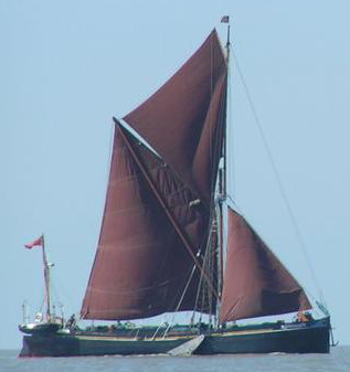
The barge’s hull was originally made of wood, later steel, and was around 90 feet (30m) long and 20 feet (6m) wide. Most of the hull was a hold for cargo, with two small living areas in the bow and stern (front and back). As the hull was flat-bottomed, the barges could float in as little as 3 feet (1m) of water, making them ideal for work in canals. In fact, they could navigate small rivers and creeks around the coast of Britain, the open sea, the river Thames and then the Surrey Canal, allowing goods to make the complete journey without being trans-shipped.
The barges had two masts with four sails, which were often rusty red in colour because of the red ochre and cod oil which was used to keep them waterproof. The masts (18m high for the main mast) were taken down when inland, so that the barges could be towed by horse, and sometimes local boys, under the low bridges on the way to Camberwell and Peckham. In later years some barges were also fitted with engines. In good conditions, sailing barges could reach speeds over 12 knots (13 miles an hour).
Cargoes varied enormously: bricks, mud, hay, bibles, lemonade, ice, sand, coal and refuse, for example. A two-person crew was enough for most voyages, though they would have to work very hard.
The barges’ heyday came around 1900 when over 2000 were registered, but by 1970 they had all but disappeared from the river and canal.

It’s great to see an article on the Surrey Canal and that the remains are being put to good use. Also I was glad that the local children could be made aware of what used to pass near to where they lived. I loved the list of their names, they were so unusual and I couldn’t have even dreamt them up, they showed that every one was a different individual and should be looked upon so.
I used to live in North London and sometimes ventured to South London and saw the demise of the Grand Surrey Canal and often wondered what use it had been put to. I’m glad that it is being put to educating children and get them use their imaginations.
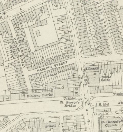
I was born and brought up in Harling Street and just round the corner from Wells Way Bridge and lived through the Blitz. We used to fish in Surrey Canal for redthroats and stickleback fish. They were small fish. The canal never saw much trade during the war although there was the odd barge full with timber. On the canal bank there were cottages and chalk pits owned by Jennings. Harling Street was L-shaped but with a short extension on the elbow which backed onto these chalk pits.
Here’s how it looked in 1913 (now the area of the BMX track)
I was born in the area, l went to Walworth School and often walked over Burgess canal footbridge to get to a good chip shop the other side of thee canal. As much as l understand the dangers of the canal, it probably was not any different from the new lake created. I think it was short sighted to abandon the canal, it could have linked the lake to the Thames for pleasure uses, but timber and refuse could have continued to have been transported if the desire was there and to reduced road transport.
Well said Lewis! I agree completely. Interestingly, Jessie Burgess herself argued in favour of keeping the canal too!