Tag Archives: Southwark Council

New Image of Bridge to Nowhere

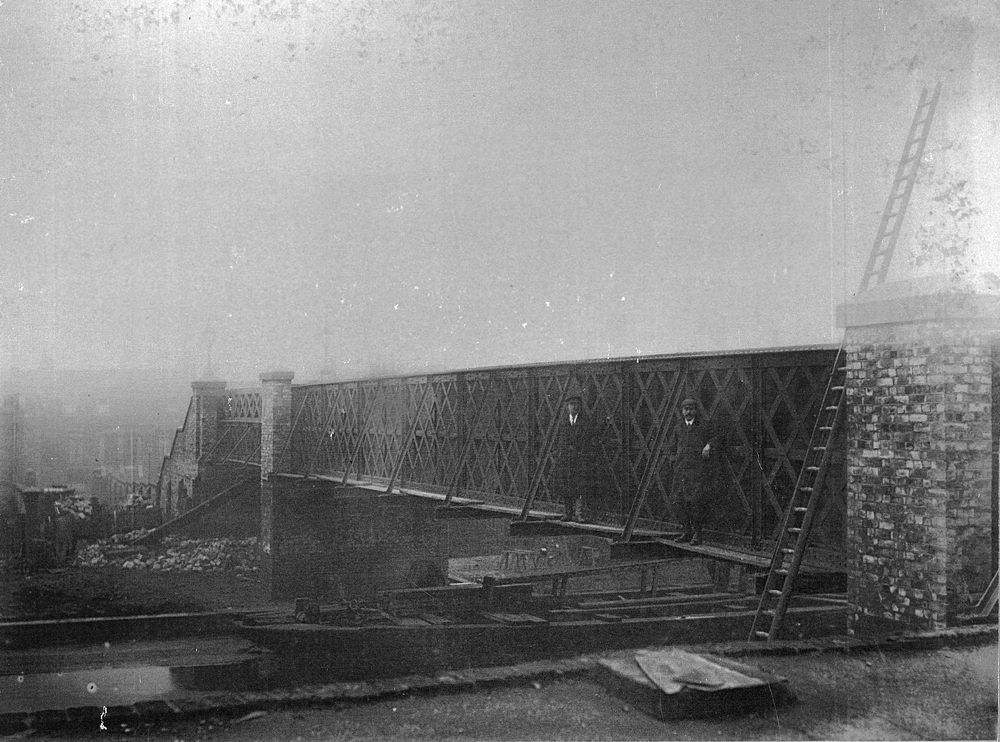
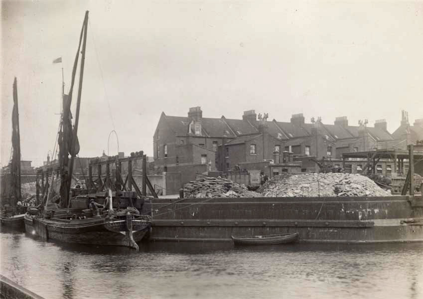
A fresh image of the Bridge to Nowhere taken during its construction has just come to the attention of this website. The image appears to have been taken as the bridge was almost complete, probably just before its opening, in the winter of 1905/6.

P 22987 ‘Surrey Canal Bridge’

The image appears in a Camberwell Book of Photographs dated 1906, put together by Camberwell Borough Council, and now part of Southwark Archives, with the reference RES OS 942.1642. The full story of the construction can be found on our page on the Bridge here.

The photograph is taken from on top of a building on the north side of the canal, looking across to the houses on St George’s Way (just visible on the left). The building would have been the sheepskin/fleece factory of Strong and Rawle at that time. This section of the canal has clearly been drained to aid the construction, with a lighter (barge) placed underneath, presumably to allow access over the otherwise muddy canal bed.

Did you spot the two gents standing on boards on the side of the bridge? Presumably working on the bridge, nevertheless they have turned out very smartly for the photographer, in suit and tie! Or perhaps they’re foremen, or one of them is even the Borough Engineer, William Oxtoby, who designed the bridge.

Enhanced image:

Trafalgar Avenue bridge

Yes – there is still a bridge taking Trafalgar Avenue over the route of the former Grand Surrey Canal! It was news to this author that the slight rise in the road where it crosses the park disguises a modern concrete replacement bridge, not merely a pile of demolished buildings.

Early Glimpse
A first glimpse of the bridge appears in 2016

It’s not quite clear (maybe someone can explain) why an expensive bridge was built, although the canal had been filled in in 1970.

Unfortunately, bridges need inspecting periodically, and when that time came around last year, it proved to be a bigger task than at first envisaged.

Typically for the development of the park, it was discovered that the void beneath the bridge had been used to dispose of all kinds of waste, including asbestos.

Works have therefore taken quite some time, and the whole space beneath has been excavated in order to build permanent inspection chambers, so that in future, the job will be a bit easier.

Cleared space beneath 2 bays of the bridge
Under-bridge area cleared – visualise a canal now?!

The brick tower next to the bridge above is a ventilation chamber for the 132kV London electricity ring-main, cables for which were laid under the park as it was being developed in the 60s or 70s.

Of course, an imaginative administration might have thought about the posibility of restoring some water to the area, in some sort of memorial to the days of the canal. However, a brick-built inspection chamber is going in and the whole are will be backfilled and restored to grass.

Glass bottle
Archaeological find


Did you spot the ubiquitous R Whites lemonade bottle in the image above? Somehow recovered intact, despite the heavy earth-movers, these can be found all over the park, wherever a hole is dug.


Wooden hump-back bridge over canal
1830 view of what was probably the first Trafalgar bridge, looking west. Glengall wharf and the Peckham branch are behind the artist/extreme left. St Georges church in the background


Council to demolish last vestiges of canal

Southwark Council has decided that the original retaining wall of Glengall Wharf should be replaced with a concrete block barrier similar to those used on motorway embankments. Flowers and plants in the gaps will look ‘nice’, but effectively erase any idea of a canal bank.

Showing old wall with rear of Glengall Terrace behind Glengall Wharf Garden
Original wall of Surrey Canal round Glengall Wharf

The existing wall is certainly not pretty, but it’s a major piece of industrial archaeology from the days when the canal ran alongside and turned down towards Peckham. Apart from the small low concrete ledge in the grass oppposite, it’s the only piece of original canal bank left on the entire three and a half mile length of the Grand Surrey Canal. It features in numerous historic photos of the area.

Black paintede wall around wharf, with 2 sailing barges
Glegall wharf around 100 years ago. ©Museum of London

In this image, you can see the black painted wall with timber fenders attached part way down. In the present-day image above and below, the black painting is still visible, with plain concrete below, where the fenders had been attached.

Two stone blocks just visible, embedded in concrete

It’s also still possible to see large stone blocks embedded in the wall, if you take a walk today. These were the footings of the large loading chutes visible in the historic image. There are 12 visible on the Peckham route, corresponding to the 6 loading chutes which were on that side of Glengall Wharf.

It seems a great shame to bury almost the last signs of industrial canal heritage for the sake of a tidy-up.

See more on the history of the wharf here.